
Illinois 131 (Green Bay Road) from Wadsworth Road to Sunset Avenue
PROJECT OVERVIEW
About This Project
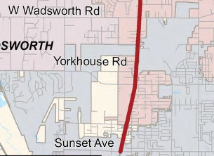
Accurate Group, Inc. (AGI) partnered as a subconsultant to HDR Engineering, Inc. on the significant reconstruction and widening of FAU 2711: IL 131 (Green Bay Road). This vital project encompassed a minor arterial and Strategic Regional Arterial (SRA) route in Lake County, specifically within the jurisdictions of the City of Waukegan and the Village of Beach Park. The project, with a total length of approximately 14,204 feet (2.69 miles), included complex infrastructure upgrades and improvements, such as traffic signal modernization, enhanced lighting, improved drainage, and the construction of a new shared-use path and pump station.
AGI’s surveying and technical expertise were essential in supporting HDR’s engineering design and execution. The following details highlight AGI’s comprehensive contributions to the project:
- Full Topographic Survey: AGI conducted a complete topographic survey of the entire project corridor, gathering detailed information on surface features, elevations, and terrain. This survey provided the engineering team with a precise and comprehensive overview of the project area, ensuring that the design and construction plans were based on accurate, up-to-date data.
- Establishment of Horizontal and Vertical Control: AGI established precise horizontal and vertical control points across the project site. These control points were critical for ensuring consistency and accuracy during construction, allowing all aspects of the project, from road widening to drainage improvements, to be executed according to plan.
- Cross Sections at 100-Foot Intervals: To further support design accuracy, AGI generated cross sections at regular 100-foot intervals along the length of the project. These cross sections provided detailed profiles of the existing roadway, surrounding terrain, and subsurface features, offering valuable insights for the engineering and construction teams.
- Drainage Survey and Invert Elevations: AGI’s drainage survey work was crucial to the project, capturing precise invert elevations of existing drainage structures. This data was used to design the improved drainage systems, ensuring effective water management and reducing the risk of flooding or water damage along the newly widened roadway.
- Culvert Survey: As part of the drainage improvements, AGI performed a comprehensive survey of all culverts within the project limits. The culvert survey provided critical data on existing structures and their conditions, aiding in decisions about replacement or enhancement to meet modern standards.
- Tree Survey: A detailed tree survey was conducted by AGI, identifying the size, species, and location of trees within the project area. This information was essential for environmental impact assessments, allowing the project to account for tree preservation or removal in compliance with local regulations.
- Field Alignment and Ties: AGI was responsible for setting the alignment and ties in the field, ensuring that the engineering designs were accurately transferred to the construction site. This step ensured that all construction elements were placed correctly according to the approved plans.
- Survey of Boring Locations: As part of the geotechnical investigations, AGI surveyed and marked the locations of all boreholes for subsurface exploration. This survey ensured accurate data collection on soil conditions, which played a critical role in determining foundation and pavement design.
- Pump Station Survey and Discharge Survey: AGI provided specialized surveying services for the new pump station being constructed as part of the project. The survey work included capturing detailed discharge elevations and flow data, ensuring the pump station would function efficiently in managing stormwater runoff.
- Septic System Pickup Survey: AGI conducted a thorough survey of any existing septic systems within the project area. This information was critical for ensuring that the new construction did not interfere with or damage existing systems, and that necessary modifications were made to accommodate the widened roadway.
- Quality Assurance (QA) Survey: Throughout the project, AGI performed rigorous quality assurance surveys to ensure that all surveying and construction activities were executed according to the highest standards. These QA surveys helped maintain accuracy, consistency, and compliance with project specifications.
- Roadway Plan Preparation including the following sheets:
- General Noted/Index of Sheets/Approved Required Notes/List of State Standards/Commitments
- Typical Sections
- Alignment, Ties, and Benchmarks
- Drainage and Utility Plans
- Erosion Control Plans
- Preparation of the Storm Water Prevention Plan (SWPPP)
- Retaining Wall Design
- Constructability Review
Comprehensive Infrastructure Upgrades
The overall project involved not only road reconstruction and widening but also a series of modern infrastructure enhancements. These included:
- Traffic Signal Modernization and Replacement: AGI’s survey data supported the redesign and placement of modern traffic signals, improving traffic flow and safety along the busy arterial route.
- Lighting and Shared-Use Path: The project also introduced modern roadway lighting and a new shared-use path to enhance safety for pedestrians and cyclists, supported by AGI’s accurate alignment and topographic surveys.
- Drainage and Pump Station: AGI’s detailed drainage and culvert surveys played a critical role in designing effective water management systems, including a new pump station to mitigate stormwater issues.
AGI’s expertise and attention to detail ensured that the project was built on a solid foundation of accuracy and compliance, contributing to its overall success.
PROJECT IMPACT
Key Outcomes
Delivered a full topographic survey across the 2.69-mile project corridor
Established precise horizontal and vertical control supporting construction
Generated cross sections at 100-foot intervals for design accuracy
Conducted drainage, culvert, and tree surveys informing engineering decisions
Surveyed the new pump station and discharge systems for stormwater management
Supported traffic signal modernization and new shared-use path design
Prepared roadway plan sheets and SWPPP documentation for the corridor
Enabled comprehensive infrastructure upgrades along a key arterial route
Project Information
Client
Illinois Department of Transportation (Sub to HDR Engineering)
Location
Lake County, IL
Project Type
Reconstruction & Widening Survey (2.69 miles)
Completion
Survey Completed 2025